Section 11: Indicators and Signs associated with Points
(Page 2 of 3)
|
From c.1950, a new form of sign to mark the location of catch points was introduced on the London Midland Region. This comprised a hollow triangle fixed at the top of a post, visible from both directions [11.29]. These signs were also provided at unworked spring points.
|
 |
[11.29] Catch Points Sign.

Area: London Midland Region
Usage: High
Status: Obsolescent
|
|
|
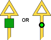
Some one-way hand spring points in yard areas (e.g. Ripple Lane) were provided with a position light type points indicator for facing movements. The indicator displayed two white lights at 45° [11.30] when the points were lying in the normal position; otherwise, no indication was shown.
|
 |
[11.30] Points Indicator - Points set correctly.
Area: Various
Usage: Low
Status: Uncertain
|
|
Several catch points between Lancaster and Carlisle were fitted with facing point locks in 1971 to enable them to be locked in the closed position during periods of pre-planned single line working. This negated the need to provide a handsignalman at the points or to restrict facing movements to 10 mph. From February 1972, the catch points concerned were identified by a square green board or a green lamp attached to the post of the catch points sign, facing to wrong-direction movements [11.31]. Facing point locks were later fitted at some other trailing points (e.g. at the exits from loops) for the same purpose, and catch points signs with a green board or lamp were provided at them.
In August 1974, British Rail introduced a standard design of sign to indicate the location of catch points, comprising a solid white triangle bearing a letter "S" (for "spring") in black [11.32]. These signs are normally double-sided and are positioned either on the approach to the points in the facing direction or at the toe of the points. These signs are also provided at unworked trailing points.
 |
 |
[11.31] Catch Points Sign.
Area: Lancaster - Carlisle
Usage: Medium
Status: Historical
|
[11.32] Catch Points Sign.
Area: All Areas except Scottish Region
Usage: High
Status: Obsolescent
|
In December 1982, the points forming the double line to single line connection at Bedford St. Johns (London Midland Region) were converted to train-operated (hydro-pneumatic) points. This style of points was developed in conjunction with innovative low-cost signalling systems employing simplified infrastructure, and this brought about a new requirement to have points indicators (applicable to facing movements) installed on running lines. Believing that these new signalling systems would be used in places so remote that no power supply would be available, the British Railways Board in London had designed a mechanically operated form of points indicator and proposed that this should be fitted as standard at all train-operated points. The face of the indicator comprised a white square with a single black stripe between opposite corners. Normally the black stripe was inclined diagonally [11.33], indicating that the points to which the indicator applied were set correctly. When the face of the indicator was rotated such that the black stripe was horizontal [11.34], it indicated that the points were not correctly set. An indicator of this type was installed at Bedford St. Johns before being transferred to the west end of the crossing loop at Achnasheen (Scottish Region) for trial purposes.
 |
 |
[11.33] Mechanical Points Indicator ('off').
Area: Bedford St. Johns / Achnasheen
Usage: Low
Status: Historical
|
[11.34] Mechanical Points Indicator ('on').
Area: Bedford St. Johns / Achnasheen
Usage: Low
Status: Historical
|
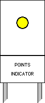
Since the mechanical points indicator at Achnasheen could not be made to work properly, and given that power supplies already existed for platform lighting and points heating, a decision was made to provide electrical points indicators as standard in future. In April 1984, the crossing loops at Garve and Arisaig on the Scottish Region were provided with simplified infrastructure in preparation for the eventual introduction of Radio Electronic Token Block (RETB) over the routes concerned. The points at each end of the loops became train-operated, and electrical points indicators were provided. Each indicator consisted of a yellow light and a plate with the words "points set". When the points were set correctly, the yellow light was illuminated [11.35]. If the light was out, the driver was required to stop and not pass over the points until they had been secured.
Another low-cost signalling system that was developed around the same time as RETB, and which also featured simplified infrastructure and train-operated points, is known as "No-Signalman Token Remote" (NSTR). Prior to this system being introduced on the Whitby line (Eastern Region), train-operated points were installed at Nunthorpe and Glaisdale in early 1986. Points indicators showing a yellow light were provided, similar to those in Scotland (see [11.35]), but their plates were worded "points indicator" [11.36].
Because NSTR lacks the radio communication facility inherent within RETB, drivers are unable to advise the signalman that their train has departed a crossing loop before a following train may be allowed to approach the same loop. Traincrews on the Whitby line must inform the signalman if their train's departure from a loop is delayed, and protect the rear of the train with detonators if necessary. The Western Region's implementation of NSTR compels the drivers of all trains arriving at a crossing loop to be prepared to find another train still occupying that loop and to stop short if necessary. Accordingly, the original points indicators installed on that region's NSTR lines (from 1986) displayed a position light 'proceed' aspect (two white lights at 45°) [11.37] instead of a yellow light, to indicate the permissive nature of the movement into the loop ahead.
 |
 |
 |
[11.35] 'Points Set' Indicator - Points set correctly.
Area: Scottish Region
Usage: Medium
Status: Current
|
[11.36] Points Indicator - Points set correctly.
Area: Eastern Region (subsequently All Areas)
Usage: Medium
Status: Current
|
[11.37] Points Indicator - Points set correctly.
Area: Western Region
Usage: Medium
Status: Obsolescent
|
|
In the early part of 1987, the train-operated points at six crossing loops on the West Highland Lines (Scottish Region) were altered to normally lie the opposite way. The ground frame operated siding connections at those places, which had hitherto trailed into the loops, became facing connections as a result. The altered normal lie of the crossing loop points was intended to ease shunting to and from the sidings, but it also had the side effect of imposing right-hand running through the loops. To remind drivers that the train-operated points lie normally to the right, a supplementary arrow sign was added to the associated 'points set' indicator [11.38]. 'Points set' indicators fitted with these signs were provided at Muir of Ord on the Far North Line in January 1988, when train-operated points lying normally to the right were installed there. The collapse of Ness Viaduct in February 1989 led to temporary arrangements being hastily introduced at Dingwall, including a change to the normal lie of the train-operated points at the north end of the crossing loop. Supplementary arrow signs were attached to the corresponding 'points set' indicators for the duration of the temporary arrangements, which ended in May 1990.
|
 |
[11.38] 'Points Set' Indicator with supplementary arrow sign.
Area: Scottish Region
Usage: Medium
Status: Current
|
|
|
Fouling point markers were provided at crossing loops on the West Highland Lines in 1987, pending the introduction of RETB. These comprised an orange cylindrical marker with a white stripe [11.39] installed at ground level between the loop lines at each end of a crossing loop. These were provided to allow trainmen to determine whether their train was within the fouling point. These markers were also installed on the lines north of Inverness.
|
 |
[11.39] Fouling Point Marker.
Area: Scottish Region
Usage: Medium
Status: Obsolescent
|
|
|
The points indicators introduced in 1988 under the Cambrian Lines RETB scheme (London Midland Region) comprised a large white board, divided into two parts by a black horizontal line. The upper part incorporated the yellow light, whilst the lower part contained the words "points indicator" [11.40].
|
 |
[11.40] Points Indicator - Points set correctly.
Area: Cambrian Lines
Usage: Medium
Status: Historical
|
|
|
Concurrent with the introduction of NSTR on the Whitby line in August 1989, a points indicator was provided on the facing-direction approach to the power-operated junction points at Battersby. When the points are set in either position for a departing train, a yellow light is exhibited along with an alphanumeric route indication (see Section 6). When the points are not correctly set for a departing train, a positive 'stop' indication is given by a red light [11.41].
|
 |
[11.41] Points Indicator - 'Stop' indication.
Area: Battersby
Usage: Low
Status: Obsolescent
|
|
In 1992/1993, the fouling points at various depots were identified by painting a sleeper at the appropriate distance from the relevant points in a bright colour (e.g. white or yellow). This was done to reduce the risk of collisions between moving stock and stock berthed in the depot.
|
In December 1994, tall posts coloured with orange and white markings [11.42] were provided to denote the fouling points between certain sidings within Inverness Traction & Rolling Stock Depot, to assist drivers with checking that their train is in clear.
|
 |
[11.42] Fouling Point Marker.
Area: Inverness
Usage: Low
Status: Uncertain
|
|


