|

|
|
|
In some places, extra measures have been implemented to guard against the possibility of an overrun occurring (i.e. prevention) or to reduce the consequences of an overrun (i.e. mitigation). An overrun can occur at a station stop or, rather more seriously, past a signal that is showing a 'danger' indication, the latter being termed a 'SPAD' - Signal Passed At Danger.
By 1846, the Eastern Counties Railway had assumed the practice of attaching fixed telegraph semaphore arms to some of the posts that supported the telegraph wires alongside the railway, as a way of indicating to drivers the distance to a station ahead.
|
In complex layouts, line identifiers were sometimes fitted to signals (particularly gantry-mounted signals) in places with many adjacent lines and signals. A line identifier was a board stating the relevant line name [8.1], which helped drivers to pick out the signal that applied to their train. |
|
To enable drivers to locate their position, the Southern Railway had a practice of installing yellow (or amber) location lights [8.2] on the approaches to passenger halts where no signals existed. These lights were commonly provided upon closure of a signal box and the consequent removal of signals from the vicinity of a passenger station. Exceptionally, the light was only displayed for trains booked to stop at the halt during darkness. At some locations, a white location light was used [8.3].
 |
 |
|
[8.2] Location Light (yellow).
Area: Southern Railway Usage: Medium Status: Historical |
[8.3] Location Light (white).
Area: Southern Railway Usage: Medium Status: Historical |
|---|
|
In December 1928, a fog location lamp was provided 50 yards (46 metres) on the approach to a signal at Borough Market Junction (Southern Railway). The lamp had a letter "F" on the face [8.4], and it was only switched on during foggy weather. It was short-lived, being removed in April 1929. |
|
In December 1928, a location board was provided 50 yards (46 metres) on the approach to signals at Vauxhall on the Southern Railway, to enable drivers to locate their position during foggy weather. This took the form of a rectangular board with alternate black and white squares [8.5]. It was replaced by a larger board bearing diagonal black and white stripes in April 1929 [8.6].
 |
 |
|
[8.5] Fog Location Board.
Area: Vauxhall, Southern Railway Usage: Low Status: Historical |
[8.6] Fog Location Board.
Area: Vauxhall, Southern Railway Usage: Low Status: Historical |
|---|
As early as 1931, countdown markers based on the Dutch 'baak' fog indicator boards were installed on the approach to a distant signal at Mexborough (LNER) [8.7].
|
|
[8.7] Countdown Markers.
Area: Mexborough, LNER Usage: Low Status: Historical |
|---|
|
Under the second stage of the LNER's resignalling at London King's Cross in October 1932, part of the layout on the west side became referred to as "A" route to "E" route. Identification letters of the 'cut-out' type [8.8] were attached to either side of the signal gantry that spanned these lines, each letter being placed directly above the corresponding line. The letters were illuminated at night. |
|
The Southern Railway provided an experimental fog location board at Earlswood in March 1933. This took the form of a large square board with black and white vertical stripes [8.9], and was installed on the skew to the Down Through line, 100 yards (91 metres) on approach to signal CR17. In November of the same year, experimental fog location posts painted white [8.10] were installed 100 yards (91 metres) on approach to two signals at Haywards Heath. The fog location board and posts at both places were removed in April 1934.
 |
 |
|
[8.9] Experimental Fog Location Board.
Area: Earlswood, Southern Railway Usage: Low Status: Historical |
[8.10] Experimental Fog Location Post.
Area: Haywards Heath, Southern Railway Usage: Low Status: Historical |
|---|
|
The Signal Engineer of the LMS, A F Bound, considered isolated distant signals (i.e. those not co-located with a stop signal) to be important markers. In 1935, he introduced the practice of painting alternate black and white stripes on their posts, where tubular steel posts were used, to make these signals more conspicuous to drivers [8.11]. The practice was discontinued in January 1960 on grounds of cost. |
|
|
In September 1943, a white indicator plate was provided on the approach to Rogate station (Southern Railway) [8.12], to allow drivers to locate their position. |
|
In September 1949, marker lights were fixed to the wall of Glasgow Queen Street High Level Tunnel (Scottish Region) to assist drivers in locating a stop signal in the tunnel in conditions of poor visibility. The signal concerned was approached on a steep downhill gradient. The marker lights comprised groups of continuously lit white lights (three at 120 yards (110 metres), two at 75 yards (68 metres), and one at 30 yards (27 metres) from the signal). The positions of the lights were altered at various times, and they were removed completely when the line was resignalled in December 1998.
In May 1952, a set of five experimental marker boards was installed alongside the Up Main line at Trent. The boards were spaced 50 yards (46 metres) apart, on the approach to the Up Distant signal.
In 1956, trials took place with the provision of countdown markers on the approach to a distant signal at Newark (Eastern Region). These examples were based on Belgian practice, comprising a series of four vertical boards with black stripes [8.13], installed at 400 metres, 300 metres, 200 metres and 100 metres on approach to the signal.
|
|
[8.13] Countdown Markers.
Area: Newark Usage: Low Status: Historical |
|---|
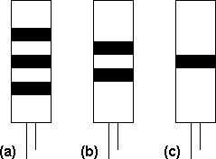
Around 1958, the Southern Region experimented with the provision of countdown markers on the approaches to certain semaphore signals to assist drivers with locating them in fog. These markers were all removed on conclusion of the trial, but markers of a different design were provided on approach to two Down direction signals at Esher East and subsequently various stop signals between Hampton Court Junction and Woking. They had horizontal black stripes on a white background [8.14] and were usually installed at 75 yards (68 metres), 50 yards (46 metres) and 25 yards (23 metres) on approach to the signal concerned.
 |
|
[8.14] Countdown Markers ( (a) - Outer board; (b) - Intermediate board; (c) - Inner board ).
Area: Hampton Court Junction - Woking Usage: Medium Status: Historical |
|---|
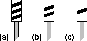
In June 1972, countdown markers were provided in the Severn Tunnel (Western Region) on the approaches to signals N166 (Down line) and N185 (Up line). These markers took the form of illuminated stencil indicators, lit only when the corresponding signal displayed a 'danger' aspect. They were installed at 900 yards (823 metres), 600 yards (549 metres) and 300 yards (274 metres) on approach to the signal and showed three, two or one diagonal bars, respectively [8.15]. In January 1974, permanently illuminated marker boards numbered "3", "2" and "1" [8.16] were provided on the approaches to both signals at distances of 150 yards (137 metres), 100 yards (91 metres) and 50 yards (46 metres), respectively. The markers were removed in July 1987 when both signals were converted to emergency red lights.
|
|
|
[8.15] Countdown Markers ( (a) - Outer board; (b) - Intermediate board; (c) - Inner board ).
Area: Severn Tunnel Usage: Low Status: Historical |
[8.16] Marker Boards.
Area: Severn Tunnel Usage: Low Status: Historical |
|---|
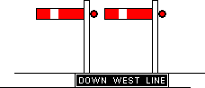
In both directions between London Bridge and New Cross (Southern Region) in April 1976, small line reminder plates were attached to the rear sides of the signal gantries, above each line, for the benefit of staff working on the track. Each plate shows an abbreviation that identifies the relevant line, in black characters on a white background [8.17]. Similar plates were also attached to the rear sides of the signal gantries between London Waterloo and Vauxhall. In addition, line reminder signs were installed at the north end of Vauxhall station, adjacent to each line, with black letters on a white background and an arrow pointing towards the relevant track [8.18].
 |
 |
|
[8.17] Line Reminder Plate (e.g. "UP MF" for 'Up Main Fast').
Area: London Bridge - New Cross / London Waterloo - Vauxhall Usage: Medium Status: Uncertain |
[8.18] Line Reminder Sign (e.g. "DN WF" for 'Down Windsor Fast').
Area: Vauxhall Usage: Low Status: Uncertain |
|---|
In 1986, a series of signs was provided to notify drivers of the approaches to Grantham and Newark North Gate stations on the East Coast Main Line (Eastern Region). A sign, showing the name of the station concerned, was installed at a distance of two miles (3.2 km) on the approach side [8.19]. Beyond this sign, countdown markers with black diagonal stripes [8.20] were erected at distances of ¾ mile (1.2 km), ½ mile (0.8 km) and ¼ mile (0.4 km) before the station.
 |
 |
|
[8.19] 'Station Ahead' Board (e.g. 2 miles to Newark).
Area: Grantham / Newark North Gate Usage: Low Status: Uncertain |
[8.20] Countdown Markers ( (a) - Outer board; (b) - Intermediate board; (c) - Inner board ).
Area: Grantham / Newark North Gate Usage: Low Status: Uncertain |
|---|
|
|